 |
|
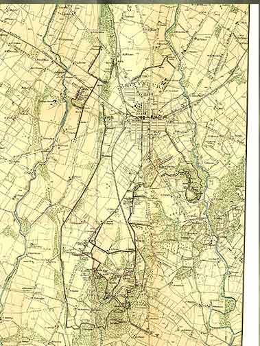
The above is a scan of a 1904 park service map, taken from the Gettysburg Discussion Group's map page. The full size map contains an abundance of information, down to the owners of all the farms. However, it takes too long to load, overflows a monitor, and is in general not the ideal map for covering specific points on a web page. |
 |
|
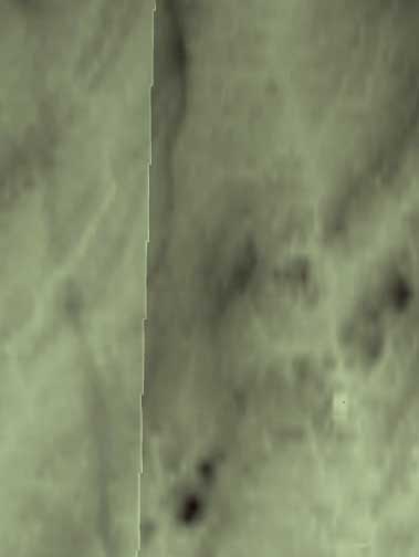
The above map is generated from US Geographical Survey digital data, imported into Bryce, a 3d modeling and graphics program. This is the base background for subsequent maps, showing low ground light, high ground dark, but lacking roads, trees, battle lines, and other useful information. Unfortunately, the battle was fought on the border between the Gettysburg (right) and Fairview (left) USGS data sections, resulting in the line running up the left center of the map. |
 |
|
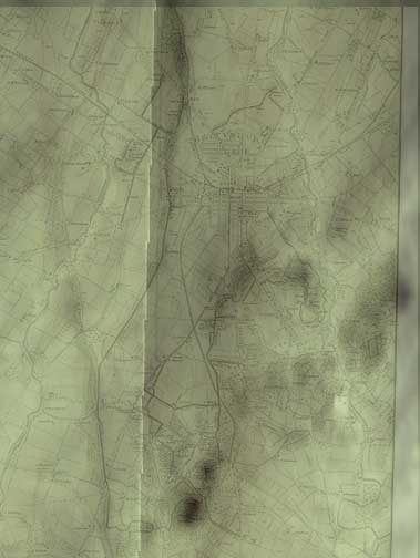
The above is a digital blending of the 1904 map with Bryce. I tried to put the streams from 1904 into the digital valleys, and succeeded within reasonable limits. Using the 1904 map for positioning points, it is possible to place battle lines, roads and other data on the Bryce maps with reasonable accuracy. |
 |
|
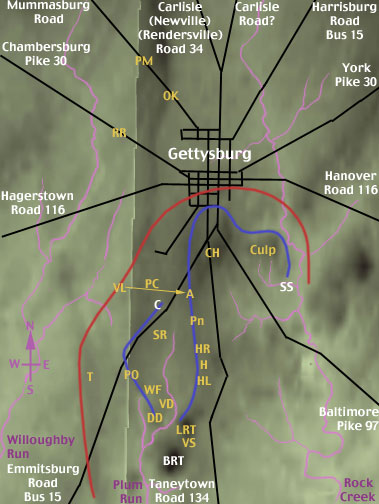
This version traces the roads from the 1904 map onto the Bryce map. The numbers following the roads are the modern route numbers. In blue, the streams are labeled. This is about as much information as I dare put on a single map designed for a web page. Thus, there are multiple versions of the map. I'm a bit confused on which is the real Carlisle Road. The older maps show the right fork going north out of town as Carlisle Road. A newer map (Trailhead Graphics) shows the left fork, Route 34, as Carlisle Road. I suspect the name changed after a road improvement project at some point since the battle. The hot points are Penn Monument (Pn), Hole Right (HR), Hole (H), Hole Left (HL), Little Round Top (LRT), Vincent's Spur (VS), Devil's Den (DD), Valley of Death (VD), Wheat Field, (WF), Peach Orchard (PO), South Tower (T), Virginia Lee memorial (VL), Pickett's Charge (PC), The Angle (A), Cemetery Hill (CH), Culp's Hill (Culp), The Rail Road Cut (RR), Oak Ridge East (OK), and the Peace Memorial (PM). In white are a few other points of interests which do not yet have picture pages. These are Spanglers' Spring (SS) and Big Round Top (BRT). |
 |
|
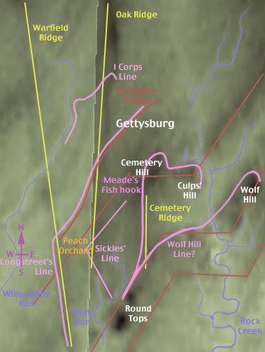
And you thought Ruffles have ridges? The famous ridges you read about in the history books mostly run north to south. They are shown in gold. This includes the well known Cemetery ridge, and the lesser known Oak and Warfield ridges. In red, is a different set of ridges, distinctly stronger, running to the northeast, but with a distinct zig zag as they cross Rock Creek. I counted Seminary Ridge as part of the northeast - southwest red ridge pattern, rather than the yellow north south, though Seminary Ridge is distinctly weaker than its sisters just southeast. In the upper left corner of the map, additional northeast - southwest running ridges are visible, continuing to echo the red pattern. In violet are several battle lines used in July 1863. Each uses one or more of the ridge lines. From Northwest to south east, we have the line defended by the I Corps on July 1, the step off position for Longstreet's assault on July 2, Sickles' advanced defensive line on July 2, and Meade's fish hook. During the night of July 2 to July 3, Meade and the Union generals considered withdrawing to a more compact line on Wolf Hill. They decided to stay at the fish hook. While I have been unable to find a map showing the proposed Wolf Hill line, my own educated guess is shown above. The Peach Orchard, the anchor to Sickles' forward line, is where Oak Ridge and the Cemetery Hill red ridge meet. It is not an insignificant position, but the Fish Hook has its points as well. Three points in particular stand out, Little Round Top, Cemetery Hill and Culp's Hill. Sickles line has nothing comparable. |
  |
|
The above patterns were used to color the USGS data. The battlefield is split between two USGS data files. Note the zigzag line running north south through the above maps. East of this line is the Gettysburg USGS data set. West of the line is Fairfield. As Fairfield contains higher hills than Gettysburg, I had to use a different color gradient in an attempt to match hill heights. While the match is decent, do not count too much on accurate color to height matching between the two map sections. |